

Christine Bradley
 The ability to chart human-caused aerosol amounts and properties over land can provide significant insights for climate and environmental studies on both global and regional scales. Various remote sensing instruments now orbit the Earth to monitor these aerosol contributions. The space-flight instruments employ different observational methods; instruments can measure light at different wavelengths reflected from the Earth (i.e. MODIS instrument), view the Earth at different angles (i.e. MISR instrument), and can measure a characteristic of light nearly undetectable with the human eye called polarization (i.e. POLDER instrument). One of the topmost challenges in aerosol information monitoring is separating two signals measured by these downward-viewing instruments: the light scattered from the aerosols and the light reflected from the Earth’s surface. In order to study the aerosols independently, the surface signal needs to be subtracted out from the measurements. Some observational modalities, such as multi-wavelength and multi-angle, do not provide enough information to uniquely define the Earth’s surface for this task. Polarization, however, can provide additional information to distinctively define this surface reflection. Christine investigates the capability of polarization measurements in outdoor scenes with a ground-based prototype camera built by NASA Jet Propulsion Laboratory, Ground- Multiangle SpectroPolarimetric Imager (GroundMSPI), which detects polarized light with 0.005 uncertainty in degree of linear polarization (DoLP). She expands upon existing surface reflectance models, such as implementing effects of multiple reflections, to compare against GroundMSPI observations and validate assumptions that have historically been used in aerosol retrieval algorithms.
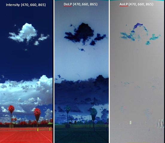
Figure 1. Example false color intensity and polarization renderings from the ground-based imaging polarimeter, Ground- Multiangle SpectroPolarimetric Imager (GroundMSPI). The intensity, degree of linear polarization (DoLP), and angle of linear polarization (AoLP) are displayed in RGB mapping where R is 865 nm, G is 660 nm, and B is 470 nm.